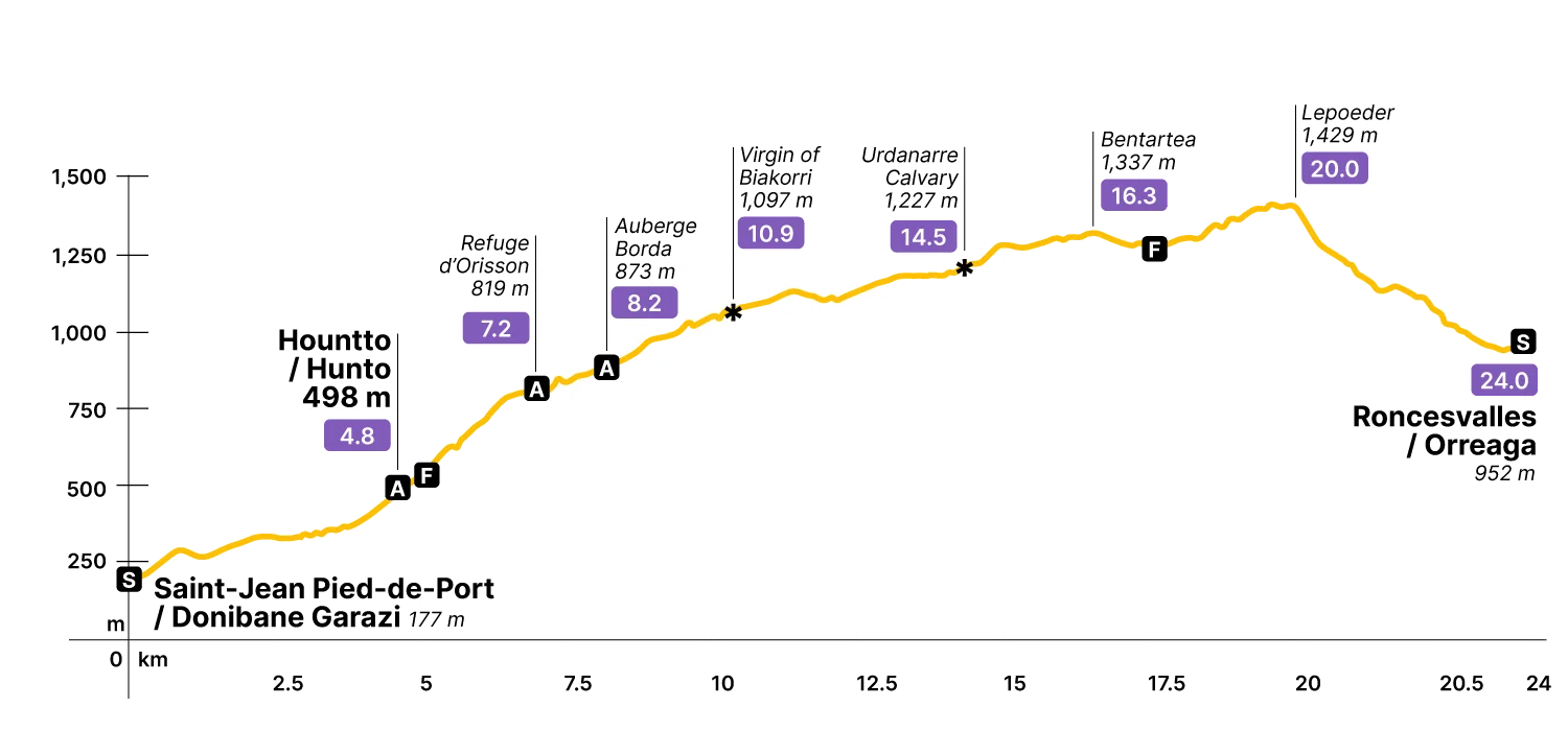
Stage Data 24 km · +1,488 m
In short
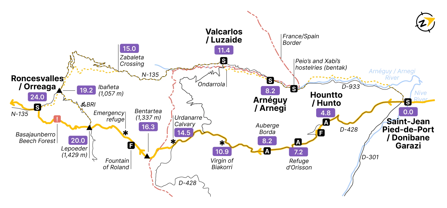
There are two ways to cross the Pyrenees from Saint-Jean-Pied-de-Port to Roncesvalles, on the other side of the mountains. The first is the Valcarlos / Luzaide variant — the historic Way of Le Puy (Via Podiensis in Latin) — which follows the valley road alongside the river Arnéguy (Arnegi in Basque). The other is the Napoleon Route, which climbs the Cize passes through the magnificent cols of Bentartea (1,337 m) and Lepoeder (1,430 m), cresting the high point of the entire French Way.
The name recalls Napoleon's armies, which crossed here during the Peninsular War of 1808–1814. This page covers the Napoleon Route: harder than Valcarlos, but one of the most dramatic days of walking on the entire Camino, with truly spectacular views across the western Pyrenees. Note that the route closes between November 1 and March 1, when snow makes it impassable. For the Valcarlos option, see its dedicated page.
Step by step
This is one of the hardest stages on the French Way — and one of the most unforgettable. Come prepared, physically and mentally: the climbing is relentless, and every hard-won meter of altitude brings the views into sharper relief.
The stage begins at the Porte d’Espagne 0.0 km, following the D-428 road marked “Route de Napoléon”. This road traces the ancient Via Aquitania, the Roman road connecting the ancient Roman cities of Burdigala (nowadays Bordeaux, in France) and Asturica Augusta (Astorga, in Spain) through the Pyrenees. The first section climbs steadily to Hountto / Hunto 4.8 km, at 498 m, home to the Ferme Ithurburia hostel.
Fill up at the fountain on the way out of the village — it’s the last reliable water for a while. Shortly after, the Camino forks off onto a rough dirt track that winds up through the hillside; both routes reach the same point, but a second fork further on is worth noting: stay on the road there. Taking the dirt track adds unnecessary climbing and ends with a sharp descent into the Orisson refuge 7.2 km. Orisson (792 m) has been a pilgrim stop since the Middle Ages, when a hospital stood here to serve travelers on what was then a genuinely dangerous crossing. Today it’s a well-run refuge kept going by its hospitalier, Jean-Jacques, and the contributions of the pilgrims who sleep here.
Leaving Orisson, the gradient eases slightly as the route climbs through open mountain terrain, with the Arnéguy / Arnegi valley to the right and the Estérençuby / Ezterenzubi valley to the left. The views are already impressive. About 1 km from Orisson, the Borda hostel 8.2 km marks the last services until Roncesvalles — nice place to stock up on food and water.
After another 3 km of climbing, a white statue appears on a rocky hilltop (1,095 m) just off the path: the Virgin of Biakorri 10.9 km, keeping watch over the western Pyrenees from her pedestal roughly halfway between Saint-Jean-Pied-de-Port and Roncesvalles. Many pilgrims stop here to rest, to reflect, or simply to take in the extraordinary views opening out in every direction.
The Camino continues parallel to the road through high meadows and the remains of the old path, reaching the Urdanarre Calvary 14.5 km — also known in France as the Croix Thibaut, or Cross of Theobald — another traditional gathering point for votive offerings. Here the route leaves the road D-428 for good, taking the dirt track to the right in continued ascent.
About 1.5 km from Urdanarre, the path reaches 1,337 m at the Bentartea pass 16.3 km. Here you’ll find the so-called Fountain of Roland, installed in reference to the Chanson de Roland — the medieval epic poem that places a great battle somewhere near these passes. Charlemagne’s army, ambushed while retreating from Zaragoza: Basques or Saracens, depending on the version, medieval propaganda being what it was. What’s certain is that armies crossed here, that people died here, and that you are now doing it with trekking poles and a weather app. The mountain doesn’t care about the difference.
The path continues through dense beech forest alongside the wire fence marking the Spanish-French border, reaching the stone milestone at the entrance to Navarre and then the Lepoeder pass 20.0 km — at 1,429 m, the highest point on the entire French Way.
By the time you reach Lepoeder, you’ll have climbed 1,257 m from Saint-Jean-Pied-de-Port. In clear weather, the summit fully earns its Basque name — “beautiful hill” — with Roncesvalles / Orreaga visible just 4 km below and the full magnificence of the western Pyrenees spread out around you.
From Lepoeder, two routes lead down to Roncesvalles: straight on through the beech forest of Basajaunberro (a steep 500 m descent), or a right turn towards the Ibañeta pass and the road.
Through the beech forest of Basajaunberro
Follow the white and red GR markers carefully — it’s easy to lose the path in this dense forest, especially in fog. The slopes are steep and the ground slippery; this is where trekking poles earn their keep. The 4 km of descent brings you directly into Roncesvalles / Orreaga 24.0 km, entering the village from the east.
Through the Ibañeta pass
The safer option, and only 400 meters longer. From Lepoeder, turn right onto the NA-2033 and follow it for just over 2.5 km to the Ibañeta pass 22.5 km, where pilgrims arriving via the Valcarlos route join the trail.
From there the Camino runs close to but off the road for another 2 km, entering the village of Roncesvalles / Orreaga from the north 24.4 km and leaving you beside the great stone mass of the collegiate church. The first walls you see are actually those of the pilgrims’ hostel — walk around the back of both to reach the N-135 and the heart of Roncesvalles.
Although no population centers are crossed in this stage, beyond those that serve as the start and finish, there are several scattered establishments that offer shelter and supplies. For services in Saint-Jean-Pied-de-Port, check this page. For services in Roncesvalles / Orreaga, check this page.
-
Gîte La Coquille NapoléonRoute Napoléon, 800 m from the start of the routePrivate inn in a traditional Basque house managed by Bixente and Lorna. 10 beds in 2 shared rooms + 2 private rooms. Community dinner. Breakfast. Laundry (€). Pets are welcome. They accept reservations and, if you need, they can pick you up at the village. Open all year round. +33662259940 | Book now
-
Gîte Zazpiak BatRoute Maréchal Harispe, 13Private inn ruled by Nathalie and Arnaud. Private rooms and shared full equipped kitchen. Laundry (€). Space for bikes. Space for horses. Community dinner. Open all year round +33631011963 | gite-zazpiak-bat.com
-
Gîte AnttonRoute Napoléon, 2 km far from Pied-de-Port14 beds in 3 rooms. 2 showers, 2 wc. Full equipped kitchen. Space for bikes. Space for horses. Community dinner. Open all year round +33665195073 | gite-antton.fr
-
Gîte Ferme IthurburiaRoute Napoléon, in Hountto / Hunto, 4 km from the start of the routePrivate hostel ruled by Jeanne. 17 beds in 4 rooms + 5 private rooms available. Full equipped kitchen. Laundry. Space for bikes. Reservations accepted. Open all year round, except from November 15 to December 20 +33559371117
-
Refuge OrissonRoute Napoléon, 7.2 km from the trailhead. Private hostel, managed by Jean-Jacques28 beds in 4 rooms. Showers of max. 5 minutes due to lack of water in the mountain. Kitchen and laundry for donation. Space for bikes. Restaurant with sandwiches / menu with vegetarian options. Open from April to October. Reservations accepted (preference to pilgrims on foot) +33559491303 | refuge-orisson.com
-
Gîte Auberge BordaRoute Napoléon, 1 km ahead from OrissonPrivate hostel in an ancient borda (shepherd’s shelter), managed by Laurent. 12 beds in 3 rooms + 1 private double room. Kitchen with refrigerator and microwave. Laundry. Space for bikes. Community dinner. Open from April to October +33661929743 | aubergeborda.com
Field notes on the churches, ruins, monasteries and small museums along this stage. In preparation.