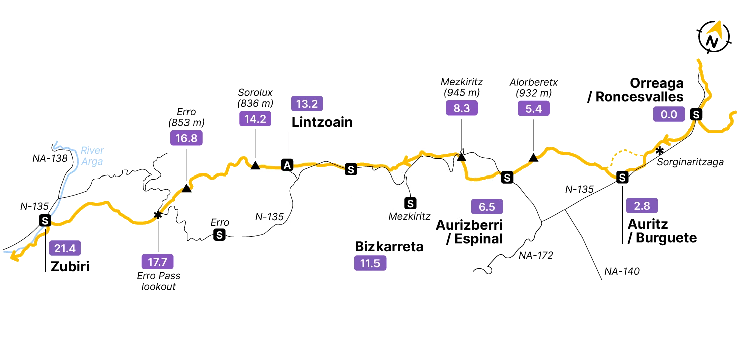
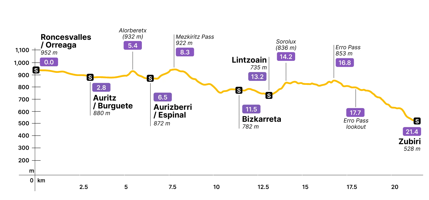
Stage Data 21.4 km · +408 m
In short
The guidebooks of a few years ago presented this second stage as a route between Roncesvalles / Orreaga and the small town of Larrasoaña / Larrasoaina, almost 27 km away. For some time now, Zubiri has emerged as a more frequent stage finish, allowing for a more balanced distribution of distances.
The result: 21.4 km of typical mid-mountain route — dirt tracks and paths dotted with stony stretches, combined with brief paved sections where the Camino runs alongside the N-135 and at a few other points.
The profile, apart from the brief ascents to Alorberetx and the Mezkiritz and Erro passes, is mostly downhill, with a total altitude loss of almost 500 m. This is no coincidence: the objective is to reach the valley of the river Arga, which will accompany you on the next stage. At several points the descent is genuinely steep — tread carefully.
Step by step
The stage begins with your back to the collegiate church of Orreaga / Roncesvalles 0.0.
From its main door and well equipped for a mid-mountain route, you briefly follow the N-135, almost to the so-called Cross of Roldan, before turning off to the right at the marked junction. The Camino continues along a dirt track running parallel to the road, a few metres off it.
This first section, up to Aurizberri / Espinal 6.5, is quite flat. Alpine meadows and humid forests of pine, oak, and beech accompany you. Their older names invoke stories well known to locals — just after leaving Roncesvalles, there’s Sorginaritzaga, also known as the “oak grove of the witches.”
In under 3 km you reach the first of the beautiful Pyrenean villages on this stage: Auritz / Burguete 2.8. With just over 200 inhabitants, it offers a good supermarket, bakery, pharmacy, and ATM, as well as a restaurant and accommodation. These places usually open early to supply pilgrims with basic necessities. If you left Roncesvalles short of anything, you’ll find it here.
The cemetery sits right on the Camino. You’ll find discoid stelae there, typical of both Celtic and Basque cultures — mostly recent works, but some considerably older. In Basque, the word for cemetery is hilerri, from hilen (dead) and herria (town): “the town of the dead.”
To leave the village, turn right in front of the bank office and cross the little Urrobi brook. You’re soon walking between pastures and livestock stables. Further on, pass through a wicket gate, with good views of the surrounding mountains.
The area is also rich in archaeological sites — menhirs, tumuli, dolmens, and other prehistoric constructions, most of them underground. They’re invisible to the untrained eye, and nothing marks them.
After Auritz / Burguete, you face a steep but easy ascent called Alorberetx 5.4 — actually the second highest point on the stage. On the descent, the next village: Aurizberri / Espinal 6.5, the first town in the Erro valley. Again: restaurant, lodging, bakery, ATM, and a bar that doubles as a grocery store. And a doctor’s office.
Leaving the village, pay attention: as you pass the small image of the Virgin of Roncesvalles 8.2, cross the road to stay on the Camino rather than taking the path climbing toward Errubelu. The yellow arrows will keep you right.
The ascent of Mezkiritz 8.3 begins immediately after Aurizberri / Espinal. The Camino doesn’t summit — it passes around it on a dirt track that narrows to a path, and you’ll feel like you’re giving back the altitude you lost over the previous kilometres. You’ll be back at 945 m above sea level (though the road sign marks 922 m) — essentially the same height as Roncesvalles / Orreaga (954 m).
From there, a series of ups and downs drops you into the Erro valley. The next village is Bizkarreta-Gerendiain 11.5. Again: shop, bar, accommodation. In the 12th century, Bizkarreta was an important stop on the route, thanks to its pilgrims’ hospital. Nothing remains of it — just a small, modern doctor’s office.
The next village is Lintzoain 12.4, a livestock farming settlement where the only service for pilgrims is an inn — keep that in mind when planning your rest stops. To get there, leave Bizkarreta parallel to the N-135, then cross it to descend to Lintzoain.
From Lintzoain, 8 km remain to the end of the stage at Zubiri. The Camino climbs steeply for 4.5 km to the Erro Pass. The steepest section — with gradients up to 19% — covers the first kilometre, up to the Soroluz Pass 14.2 (835 m). The hardest climb on the entire stage, but it doesn’t last long.
Above it, the gradient eases considerably. At the Erro Pass 16.8, 850 m above sea level, you meet the N-135 again — cross it to begin the long descent to Zubiri. Between April and October, there’s often a food truck here with drinks, fruit, and pastries. Worth a stop before the final descent.
Watch your footing from here, especially after the Erro Pass lookout 16.9. From there: 279 m of descent in 3.5 km, with gradients reaching −21%.
The descent ends at the “bridge of the rabies” over the Arga river, bringing you to the gates of Zubiri 21.4, which has a good range of services. The Camino doesn’t actually pass through Zubiri — you need to cross the bridge — but the deviation is short.
That’s the stage, though the traditional route continued 5.5 km further to Larrasoaña / Larrasoaina. If your next stop is Pamplona, Zubiri makes more sense — better balance across stages.
Lodging data for this stage is being added. Check back soon.
Field notes on the churches, ruins, monasteries and small museums along this stage. In preparation.